-mono-white MH-cropped-h99")
The Role of LIDAR and Thermal Cameras in Modern Disaster Management
Revolutionizing Damage Assessment with LIDAR
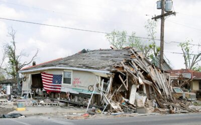
The integration of advanced imaging technologies in damage assessment has revolutionized the field of disaster management. Among these technologies, LIDAR (Light Detection and Ranging) stands out for its ability to provide precise, high-resolution maps of affected areas. In rapidly developing regions such as Saudi Arabia and the UAE, particularly in urban centers like Riyadh and Dubai, LIDAR technology plays a crucial role in identifying and assessing damage in hard-to-reach areas.
LIDAR works by emitting laser pulses and measuring the time it takes for the light to return after hitting an object. This process generates detailed 3D maps that can reveal the extent of structural damage and changes in terrain. In Riyadh, for example, LIDAR can be deployed to quickly assess the damage following an earthquake, allowing emergency responders to prioritize areas that require immediate attention. This capability significantly enhances the efficiency and effectiveness of disaster response efforts.
The use of LIDAR in disaster management is not limited to urban areas. It is also invaluable in assessing damage in remote and inaccessible regions. By providing accurate data on the topography and structural integrity of these areas, LIDAR helps ensure that no location is overlooked during disaster response. This comprehensive approach to damage assessment underscores the transformative potential of advanced imaging technologies in safeguarding communities.
Thermal Cameras: A Critical Tool for Damage Assessment
Thermal cameras are another essential component of advanced imaging technologies in damage assessment. These cameras detect infrared radiation, allowing them to visualize heat patterns and identify anomalies that may indicate damage. In cities like Dubai, thermal cameras are used to assess the structural integrity of buildings, detect hidden fires, and locate survivors in collapsed structures.
The ability of thermal cameras to see through smoke and debris makes them particularly valuable during the immediate aftermath of a disaster. For instance, in the event of a fire, thermal cameras can help firefighters locate hot spots and extinguish them more effectively. This capability not only enhances the safety of emergency responders but also increases the likelihood of saving lives and property.
In addition to their use in emergency response, thermal cameras are also employed in ongoing damage assessment and maintenance. By regularly monitoring the thermal signatures of critical infrastructure, authorities in Riyadh and Dubai can identify potential issues before they escalate into major problems. This proactive approach to maintenance helps ensure the long-term resilience and safety of urban environments.
The Role of Artificial Intelligence in Imaging Technologies
Artificial Intelligence (AI) plays a pivotal role in enhancing the capabilities of advanced imaging technologies in damage assessment. AI algorithms can process the vast amounts of data generated by LIDAR and thermal cameras, identifying patterns and anomalies that may be missed by human analysts. This advanced processing power is essential for making real-time decisions during disaster response.
In Dubai, for example, AI-driven imaging technologies can quickly analyze data from multiple sources to provide a comprehensive overview of the damage. This rapid analysis allows emergency responders to deploy resources more effectively, prioritizing areas that need immediate attention. Furthermore, AI can continuously learn from new data, improving its accuracy and reliability over time.
The integration of AI with LIDAR and thermal cameras also facilitates better coordination among various agencies involved in disaster management. By providing a unified platform for data analysis and sharing, AI ensures that all stakeholders have access to the same accurate and up-to-date information. This collaborative approach enhances the overall effectiveness of disaster response efforts, making cities like Riyadh and Dubai more resilient to natural and man-made disasters.
Future Prospects: Advancing Damage Assessment Technologies
The future of advanced imaging technologies in damage assessment looks promising, with continuous advancements in AI and sensor technology. Future imaging systems will likely offer even greater accuracy and resolution, enabling more detailed assessments of damage in complex urban environments. These advancements will be particularly beneficial for rapidly growing cities like Riyadh and Dubai, where maintaining infrastructure resilience is a top priority.
In addition to improvements in existing technologies, new imaging modalities are also being developed. These include hyperspectral imaging, which can provide detailed information about the material composition of structures, and drone-based imaging systems that can access hard-to-reach areas more easily. By integrating these new technologies into disaster management frameworks, authorities can further enhance their ability to assess and respond to damage.
Moreover, the combination of advanced imaging technologies with other innovations such as the Internet of Things (IoT) and blockchain will create a more robust and secure disaster management system. IoT devices can provide real-time data from multiple sources, while blockchain ensures the integrity and transparency of this data. This integrated approach will enable more accurate and efficient damage assessments, ultimately enhancing the resilience of communities to disasters.
Conclusion: Embracing Advanced Imaging Technologies for Effective Damage Assessment
The integration of advanced imaging technologies in damage assessment is revolutionizing the field of disaster management. By leveraging technologies such as LIDAR, thermal cameras, and AI, countries like Saudi Arabia and the UAE are enhancing their ability to respond to and recover from disasters. These innovations ensure that damage assessments are accurate, comprehensive, and timely, enabling more effective emergency response efforts.
As we continue to advance in this field, the role of leadership and effective project management cannot be overstated. Business executives, mid-level managers, and project leaders must collaborate to ensure the successful implementation and maintenance of advanced imaging technologies. Their efforts will not only enhance public safety but also demonstrate the transformative power of modern technology in disaster management.
In conclusion, the future of damage assessment is bright, with advanced imaging technologies at the forefront of this evolution. By prioritizing innovation and collaboration, we can create a safer and more resilient world, where communities are well-prepared to face the challenges posed by natural and man-made disasters.
#AdvancedImagingTechnologies, #LIDAR, #ThermalCameras, #DamageAssessment, #ArtificialIntelligence, #ModernTechnology, #BusinessSuccess, #LeadershipSkills, #ProjectManagement