-mono-white MH-cropped-h99")
Combining GIS Technology with Flood Warning Systems for Better Visualization and Analysis
Understanding the Role of GIS in Flood Warning Systems
Integration of flood warning systems with GIS technology is revolutionizing the way we manage and mitigate flood risks. Geographic Information System (GIS) technology enables the visualization, analysis, and interpretation of data to understand relationships, patterns, and trends. By integrating this technology with flood warning systems, we can achieve a more comprehensive understanding of flood risks and improve our ability to respond to potential disasters. This integration is particularly crucial in regions like Saudi Arabia and the UAE, where urban centers such as Riyadh and Dubai are prone to flash floods due to their unique geographical and climatic conditions.
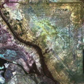
GIS technology provides a platform for mapping flood-prone areas, which is essential for effective disaster management. These maps can highlight vulnerable regions, allowing authorities to implement targeted mitigation strategies. For instance, AI-powered flood warning systems can process real-time data from various sensors and predict potential flooding events with high accuracy. When this data is integrated with GIS maps, it provides a clear visual representation of at-risk areas, enabling quick and informed decision-making.
Moreover, the integration of blockchain technology with flood warning systems enhances the reliability and transparency of data. Blockchain ensures that all data is securely recorded and immutable, which is crucial for maintaining trust among stakeholders. This transparency is essential for coordinated disaster response efforts, as it ensures that all involved parties have access to accurate and up-to-date information.
Advancing Flood Risk Management through Technology
The integration of flood warning systems with GIS technology supports the visualization and analysis of flood risk areas, enabling more effective flood risk management. In cities like Riyadh and Dubai, where rapid urbanization increases the risk of flooding, such advanced systems are indispensable. By leveraging modern technology, these cities can better prepare for and respond to flooding events, minimizing the impact on their residents and infrastructure.
Artificial intelligence plays a significant role in enhancing the accuracy of flood warning systems. Machine learning algorithms can analyze complex data sets from various sources, such as weather forecasts, river levels, and soil moisture content, to predict flooding events. When integrated with GIS technology, this data can be visualized in real-time, providing a clear picture of flood risk areas. This real-time visualization allows for timely and effective responses, potentially saving lives and reducing economic losses.
Additionally, the metaverse and generative AI offer new possibilities for flood risk management. Virtual reality simulations can create immersive training environments for emergency responders, allowing them to practice their skills in realistic flood scenarios. This hands-on experience is invaluable for improving preparedness and response capabilities. By integrating these advanced technologies with flood warning systems and GIS, Saudi Arabia and the UAE are setting new standards in disaster management.
Implementation of Integrated Flood Warning Systems
Implementing the integration of flood warning systems with GIS technology requires a multi-faceted approach that involves various stakeholders. Government agencies in Saudi Arabia and the UAE play a crucial role by providing the necessary regulatory support and funding. These agencies can facilitate the deployment of advanced technologies by collaborating with research institutions and private companies. This collaboration ensures that the latest innovations are utilized to enhance flood risk management.
Leadership and project management skills are essential for the successful implementation of these integrated systems. Effective leaders can coordinate the efforts of different stakeholders, ensuring that all parties work towards a common goal. They can also navigate the complexities of managing large-scale projects, balancing the needs of various partners while maintaining a clear vision for the future. By fostering a culture of innovation and collaboration, leaders in Riyadh and Dubai are driving progress in flood risk management.
Furthermore, the private sector plays a critical role in advancing the integration of flood warning systems with GIS technology. Private companies bring innovation and agility to the table, often leading the development of new technologies and applications. By working closely with government agencies and research institutions, these companies can ensure that their solutions are effectively implemented and utilized. This public-private partnership is essential for achieving comprehensive and effective flood risk management.
Benefits of Integrated Flood Warning Systems
The benefits of integrating flood warning systems with GIS technology are manifold. Firstly, it enhances the accuracy of flood predictions, allowing for timely and effective responses. This can significantly reduce the impact of flooding events on communities and infrastructure. Secondly, it improves the visualization and analysis of flood risk areas, providing a clear and comprehensive understanding of potential hazards. This enables authorities to implement targeted mitigation strategies and better allocate resources.
Moreover, the integration of advanced technologies such as AI and blockchain enhances the reliability and transparency of data. This fosters trust among stakeholders and ensures that all parties have access to accurate and up-to-date information. In the context of Saudi Arabia and the UAE, where rapid urbanization increases the risk of flooding, these benefits are particularly valuable. By leveraging these technologies, these countries can enhance their disaster preparedness and response capabilities, ensuring the safety and well-being of their residents.
Conclusion: Paving the Way for Advanced Flood Risk Management
The integration of flood warning systems with GIS technology represents a significant advancement in flood risk management. By leveraging modern technologies such as AI, blockchain, and the metaverse, Saudi Arabia and the UAE are setting new standards in disaster preparedness and response. These integrated systems provide a comprehensive understanding of flood risks, enabling timely and effective responses that minimize the impact of flooding events.
Effective leadership and project management are essential for the successful implementation of these integrated systems. By fostering a culture of innovation and collaboration, leaders in Riyadh and Dubai can drive progress in flood risk management. The collaboration between government agencies, research institutions, and private companies is crucial for developing and deploying advanced technologies that enhance flood risk management.
In conclusion, the integration of flood warning systems with GIS technology is a testament to the commitment of Saudi Arabia and the UAE to safeguarding their citizens and infrastructure. By leveraging modern technologies and fostering collaboration among various stakeholders, these countries are paving the way for advanced flood risk management. This holistic approach not only minimizes the impact of flooding events but also saves lives and reduces economic losses, ensuring a safer and more resilient future for all.
—
#IntegrationOfFloodWarningSystems, #GIStechnology, #FloodRiskManagement, #SaudiArabia, #UAE, #Riyadh, #Dubai, #ArtificialIntelligence, #Blockchain, #TheMetaverse, #GenerativeAI, #ModernTechnology, #BusinessSuccess, #LeadershipSkills, #ProjectManagement